


Researchers bid to unlock mystery of shrinking mountain peaks
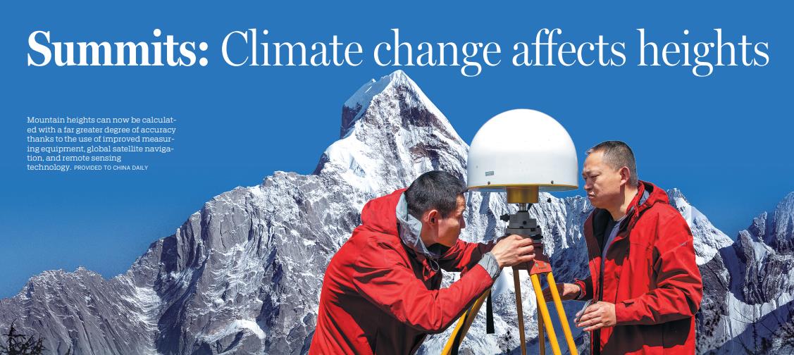
Mountain heights can now be calculated with a far greater degree of accuracy thanks to the use of improved measuring equipment, global satellite navigation, and remote sensing technology. [Photo/CHINA DAILY]
Natural forces play significant role in reduced elevations
Mountain peaks, with their majestic beauty, have long fascinated adventurers and scientists alike.
In China, Sichuan province boasts stunning and spectacular scenic areas that include snow mountains, glacial lakes, rivers and virgin forests.
Recently updated data relating to nine mountains in the province highlights changes witnessed by these peaks, and their causes.
Information about the heights of the nine peaks, which include Mount Gongga, Mount Siguniang, Mount Luoji and Mount Guangwu, was last updated some 60 years ago.
The new data, which was released by the Ministry of Natural Resources and the National Forestry and Grassland Administration, and which includes the height of the snow surface on the peaks, shows that most of the mountains have shrunk by several meters.
The height of Mount Gongga, which is known as the "King of Sichuan mountains" and is the highest peak in the province, has fallen by nearly 50 meters from 7,556 meters to 7508.9 meters.
Gui Muzheng, senior engineer at the Ministry of Natural Resources' Third Institute of Aerial Survey and Remote Sensing in Chengdu, capital of Sichuan, said: "That's quite a significant reduction. Due to earthquakes and other geological events in Sichuan, we need to provide accurate and up-to-date information to the government and the public for educational purposes and administrative planning.
"Compared with the 1960s, the accuracy of mountain peak elevation measurements has been enhanced with improved measuring equipment, global satellite navigation, and remote sensing technology," she said.
In addition, a number of natural factors play important roles in shaping mountain summits, including the impact of movement of the Earth's crust, climate change, and weathering, Gui added.
Sichuan, located on the southern edge of the Tibetan Plateau, is a particularly active tectonic zone, she said.
In recent years, the province has experienced significant earthquakes — including the 8.0 magnitude quake that hit Wenchuan county in 2008. Such events have altered the heights of these peaks.
Gui said the combined natural forces of wind and rainfall erode rocks and break down exposed surfaces. Over time, this can result in a reduced elevation of mountain peaks.
Climate change also plays a crucial role in shaping mountain summits, Gui said, adding that the retreat of glaciers and reduction in the thickness of snow cover contribute to changes in elevations.
A study by the provincial government, titled "Latest Investigation and Research on Modern Glacial Resources in Western Sichuan", found that the area of mountain glaciers in the province's western region fell by 22.1 percent from 1966 to 2020. Covering 593 square kilometers in 1966, the glaciers now occupy only 462 sq km.

Surveyors from Chengdu, capital of Sichuan province, set out to measure mountain peaks. [Photo/CHINA DAILY]
High sensitivity
Among the mountain ranges affected, the glaciers on Mount Gongga are good examples of monsoonal temperate glaciers.
Liu Qiao, a researcher at the Chinese Academy of Sciences' Institute of Mountain Hazards and Environment, said temperate glaciers are highly sensitive to climate change.
Long-term observations by Liu, who began his glaciology research when he was a master's student in 2002, confirm the accelerating retreat of the Hailuogou Glacier on Mount Gongga.
During their fieldwork, researchers discovered that the glacier has undergone significant changes.
"The entire area of the glacier, including the ice tongue, has experienced apparent thinning, narrowing and retreat. The glacier's valley is now filled with fragmented ice, indicating substantial shrinkage," Liu said.
Known for its 1,080-meter-high icefall, the glacier has experienced remarkable thinning and slowdown, resulting in the detachment of its lower debris-covered ice tongue from the icefall since 2013. Once the two sections of ice are detached, the lower ice tongue will become a separate regenerated glacier, Liu said.
"The disconnection of the Hailuogou Glacier may be irreversible," he said.
Icefall refers to a portion of certain glaciers characterized by relatively rapid flow and a chaotic crevassed surface, caused in part by gravity.
From 1966 to 2009, the Hailuogou Glacier retreated at an average rate of 25-30 meters annually. However, from 2016 to last year, it retreated by more than 50 meters per year. Liu said this rapid shrinkage surpasses the retreat rate of typical continental glaciers in China.
Previously, snowfall replenished the glaciers, but the present shift toward increased rainfall at high altitudes is insufficient for the ice mass to accumulate, he said.
Climate records indicate a consistent warming trend in Sichuan since 1961.The province's average annual temperature last year rose to 15.9 C, surpassing the previous record held since 1961 by 0.7 C, the Sichuan Meteorological Service said.
Last year, the average annual precipitation in Sichuan was 12 percent below the long-term average.
"This decrease in precipitation, together with the rise in temperature, has caused the altitude of the glacier equilibrium line to rise," Liu said.
The equilibrium line is roughly equivalent to the snow line, and frequently varies over short distances from year to year on a specific glacier.
Glacier mass balance refers to the balance between ice gain and loss from the glacier system. Above the equilibrium line, the gain surpasses the loss, while below the line, the opposite situation pertains.
In the Mount Gongga area, the equilibrium line has reached altitudes of 5,200 to 5,300 meters, while in the 1990s, the line stood at about 4,800 meters, Liu said.
Collapsing and destabilizing not only occurred on glacier ice itself, but also on the surrounding terrain, Liu said.
When a glacier is thinning, the slopes on both sides of its valley are exposed and become unstable.
Disconnected trail
Several years ago at Lao Guanjingtai in Hailuogou, tourists could trek down moraine slopes, but now significant glacial retreat and failure of these slopes have resulted in the trail to the glacier becoming disconnected from the forest, Liu said.
Meanwhile, the retreat of glaciers has caused significant changes to the water flow of rivers, giving rise to various disasters, Liu said.
When flooding occurs, moraine materials consisting of unstable glacial deposits combine with water, resulting in the flow of glacial debris that can cause severe destruction. Infrastructure along riverbanks, including roads and bridges, is particularly susceptible to such damage, Liu added.
In addition, the flooding can cause significant damage to hydroelectric power stations.
Recent observations suggest that Mount Gongga and other peaks may be experiencing a decrease in their heights due to melting glaciers and an associated reduction in glacial mass.
Liu said that while the possibility of peaks experiencing such a reduction due to glacial melting cannot be ruled out entirely, the current evidence does not provide definitive proof.
"The ongoing process of glacial melting, and the subsequent decrease in glacial ice mass, can potentially contribute to a reduction in the altitude of mountain peaks. But without direct ground measurements, the notion that declining snow cover is the primary cause of such decreasing altitudes remains to be ascertained," Liu said.
"There is no data about changes to ice and snow thickness at mountain summits," he added.
To the contrary, some theories suggest that as glaciers experience loss of mass, the pressure on their underlying crust is reduced, causing the heights of mountain summits to rise, he said.
Photos

Related Stories
- China's largest fishery scientific research vessel sets sail for the first time to investigate fishery resources
- Sunrise scenery on Gangshika snow peak in Qinghai
- Discover undeniable charms of Hongcun Village in Anhui Province
- Crystal ice drifts in Heihe River
- Fish-like patterns emerge in desert's sunlight
- China issues reports on 2023 research fronts
Copyright © 2026 People's Daily Online. All Rights Reserved.
