


Technologies, smart system facilitate flood prevention in China
This year, China has experienced frequent heavy rainfall over extended periods, with river floods occurring early and developing rapidly, making the flood control situation severe and complex.
In response, regions across the country have strengthened their technological defenses by accelerating the construction of a “smart flood control” system, providing solid technological support for modern flood prevention.
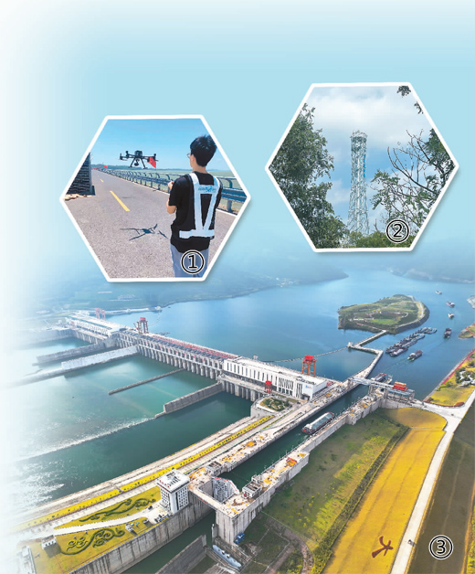
① : File photo shows a staff member of Jiangxi Aero Future Technology Innovation Co., Ltd. flying a drone to collect data of a dike in Hukou county, east China's Jiangxi Province.
②: Photo shows a precipitation measurement radar near the Lugou Bridge flood diversion area in Beijing. (Photo/Zhang Youjia)
③: Photo shows the Dateng Gorge water conservancy project in Guiping city, south China’s Guangxi Zhuang Autonomous Region. (Xinhua/Zhou Hua)
One key part of a “smart flood control” system is prediction, and one program is making huge progress on that front through the use of “simulated” floods.
The Dateng Gorge Water Conservancy project in Guiping city, south China’s Guangxi Zhuang Autonomous Region, serves as a key flood control hub for the Pearl River basin.
Affected by heavy rainfall, four floods occurred in the Xijiang River in the Pearl River basin from late June to early July, putting pressure on the Dateng Gorge Water Conservancy project.
At the dispatch center of the project, water management engineer Li Ying stared at a monitoring screen. “The digital twin system for water resources management has played a crucial role in this year’s flood prevention efforts,” Li said.
The digital twin system uses technologies like big data, cloud computing, and artificial intelligence to create a virtual version of rivers, lakes, and water conservancy projects in the digital world, which can predict the development of possible floods and support precise decision-making.
The digital twin system has the capability to make forecasts, issue early warnings, conduct simulations and draft contingency plans, Li noted.
“We managed to forecast floods 10 days in advance and accurately predicted water level increases 48 hours ahead for four floods in the mainstream of the Xijiang River during this year’s flood season,” Li added.
The Dateng Gorge Water Conservancy project epitomizes China’s constant efforts to accelerate the development of the digital twin system for water resources management in recent years. Digital twin platforms have been built for the seven major rivers, including the Yangtze, Yellow, and Huaihe, in an accelerated manner, providing effective support for flood control and management.
Another important tool seeing increased use for flood prevention are drones. They are becoming key on the frontline of flood control and for emergency response teams due to their efficiency, flexibility, and precision.
On July 18, a drone flew at a steady speed above the Suokou Reservoir in Jiuzhi township, Hejiang county, southwest China’s Sichuan Province. It collected oblique photography data of the reservoir, which was used to create VR panoramas of risk points for flood control and disaster mitigation, as well as 3D modeling.
On July 28, a breach occurred in the Sixin dike in Yisuhe township, Xiangtan city, central China’s Hunan Province. At the rescue site, a staff member operated a drone to collect 360-degree panoramic images of the breach area, providing crucial data support for the subsequent efforts to seal the breach.
These drones allow flood prevention workers to reach and see areas that were impossible before, allowing for much more complete and precise information in their battle against floods.
In addition to focusing on tools to monitor and manage floods, there is a major effort to better monitor precipitation.
Since last year, regions across China have accelerated the deployment of precipitation measurement radars in areas prone to rainstorms and floods in key river basins, major water conservancy projects, and areas prone to disasters from mountain torrents. These radars ensure precise monitoring and forecasting of rainfall and water conditions.
Compared to the traditional flood forecasting system, precipitation measurement radars can extend the flood forecast period, according to Wang Lin, chief hydrological forecaster with the Ministry of Water Resources.
Since the start of this year’s flood season, Hunan Province has successfully predicted water level changes in small and medium-sized rivers, including the Jinjing River and Guitang River, according to precipitation forecasts based on precipitation measurement radars, providing departments of water resources with crucial information for decision-making.
Going forward, the Ministry of Water Resources will focus on promoting the deployment of precipitation measurement radars in small and medium-sized rivers and areas prone to rainstorms and floods to improve the accuracy of precipitation forecasts, Wang said.
Photos


Related Stories
- Dike breach sealed in north China's Inner Mongolia
- 3 drowned in flooded river in east China's Jiangxi
- Flood-disrupted railway resumes traffic in western China
- Communication, power supplies largely resume in flood-hit Chinese city
- China allocates 649 million yuan for flood response, disaster relief
- NW China's Xinjiang mobilizes emergency responding teams for flood control amid water level alert
- 10 killed, 17 missing in southwest China flash flood, mudslide
Copyright © 2026 People's Daily Online. All Rights Reserved.
