


First International Summit on BDS Applications held in China
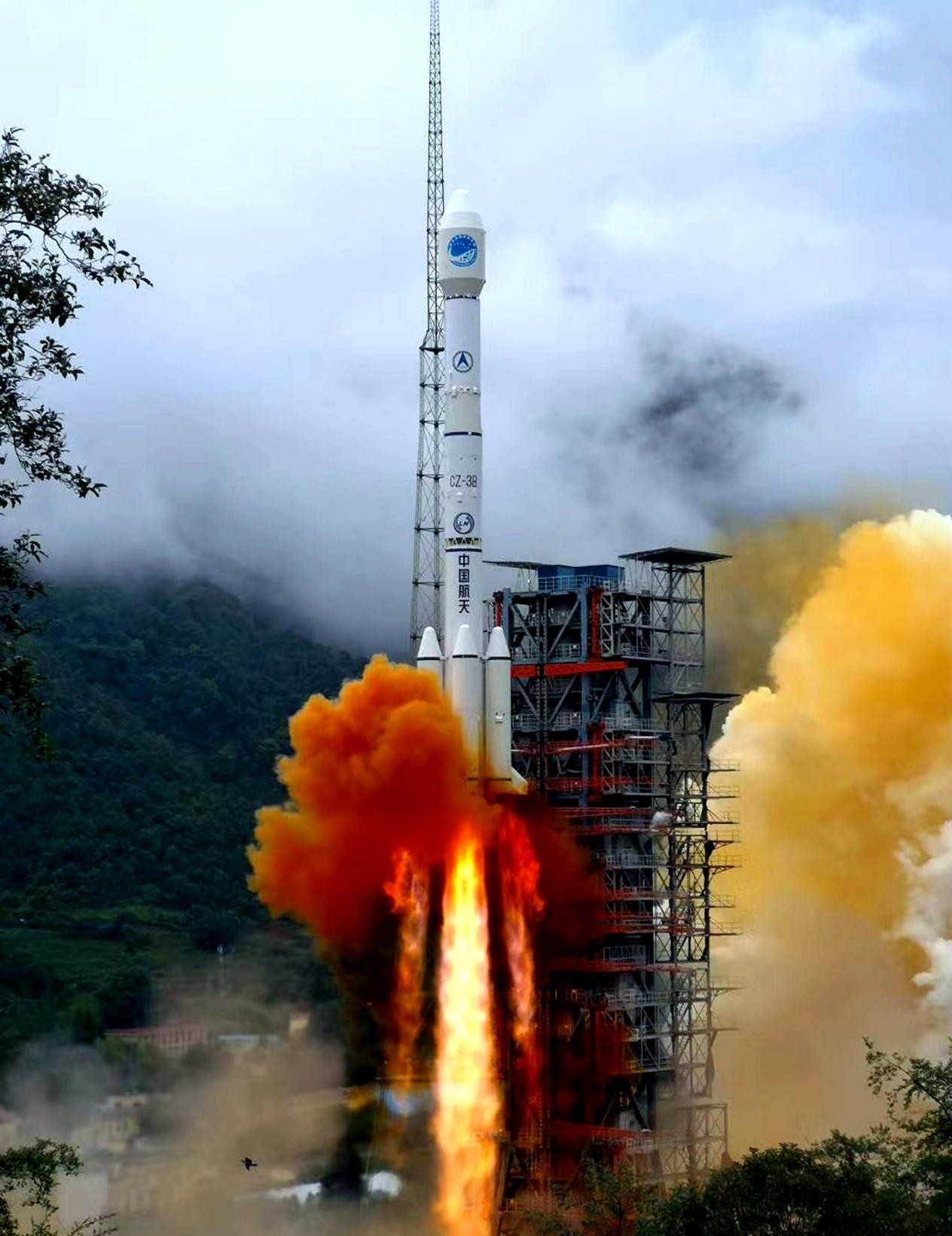
A carrier rocket carrying the last satellite of the BeiDou Navigation Satellite System (BDS-3) blasts off from the Xichang Satellite Launch Center in southwest China's Sichuan Province at 9:43 am, June 23, 2020. (Photo by Li Jieyi/People's Daily Online)
The first International Summit on BeiDou Navigation Satellite System (BDS) Applications, themed "BDS serves the world, application fuels the future," was held in Changsha, central China's Hunan province on Sept. 16 and 17.
China's BDS system has realized compatibility and interoperability with other Global Navigation Satellite Systems (GNSS), and will promote the development of today's navigation and positioning, as well as timing technologies, and lay a solid foundation for the development of a more flexible, solid and elastic structure of the navigation satellite technology, said Simonetta Di Pippo, Director of the UN Office for Outer Space Affairs, in a video message to the summit. This summit would make a contribution to the international application of space technologies, she added.
The BeiDou Navigation Satellite System, or what's known as BDS-3, was officially commissioned on July 31, 2020, marking the completion of a satellite constellation fully and independently developed by the Chinese.
However, the BDS benefits not only the Chinese, but also the entire world. At present, it has been applied in over half of the countries and regions around the world.
As a matter of fact, the BDS has been gradually introduced to other parts of the world and started serving other countries' socioeconomic development and infrastructure construction since the second phase of the project, or the BDS-2 was completed in 2012.
In 2013, the Ministry of Agriculture, Livestock and Irrigation of Myanmar purchased hundreds of BDS/GNSS receivers to collect agricultural data and manage land across the country.
Two years later, BDS high-precision receivers were used in the construction of a 300-meter-high headquarters for the National Bank of Kuwait. Receiving BDS signals ensured millimeter-level measurement error in the vertical direction during the construction, and it marked the first time that the BDS navigation and positioning technology was applied to high-rise building monitoring overseas.
The information integration system for Pakistan’s new Islamabad International Airport commenced its construction in 2017, and the BDS was applied for high-precision timing services. In 2018, 1,046 high-precision GNSS receivers powered by the BDS were used in the survey and construction of land right confirmation, road, railway and water conservancy projects in Indonesia.
So far, BDS products have been exported to over 120 countries and regions, providing services for more than 100 million users.
The BDS belongs to China, and the world, too, said Mohamed Ben Amor, Secretary-General of the Arab Information & Communication Technologies Organization. He noted that the organization will support the construction of the BDS and promote the system in all Arab countries and even beyond, so as to expand the influence of the system and its application, enhance the system's application, and benefit local communities.
The powerful performance of the BDS is why the system has such a big presence in international and domestic socioeconomic construction. The positioning accuracy of the system has reached 2.5 meters horizontally and 5.0 meters vertically. Its velocity accuracy is 0.2 meters per second, while its timing accuracy stands at 20 nanoseconds. As for global short message communication services, the service capability is 40 Chinese characters per message (560 bytes), and the number goes up to 1,000 when it comes to short message communication services in China and surrounding areas. The BDS also offers distress alerts acknowledgement services. Besides, the satellite-based augmentation and ground augmentation services of the BDS system can provide high-precision positioning with centimeter-level accuracy in real-time processing and millimeter-level accuracy in post-processing.
At present, the BDS-3 offers seven kinds of services, introduced Chen Gucang, deputy director of the China Satellite Navigation Office. Since its formal commission in July 2020, the BDS-3 has maintained steady operation and top-class service performance, he added.
With expanding application areas and the rising number of applications, the BDS has been widely used in transport, public security, disaster relief, agriculture, forestry, husbandry, fishery, and urban governance, and integrated into power, finance and communication infrastructures. It is also powering consumer goods, the sharing economy, and the livelihood sector.
Now, there are around 14,000 enterprises and institutions in China doing businesses related to the BDS, with over 500,000 employees. During China’s 13th Five-Year Plan period (2016-2020), the average annual growth of the output of the Chinese satellite navigation and positioning industry exceeded 20 percent, and the output value of the industry hit 403.3 billion yuan ($62.39 billion) last year.
 |
Photos


Related Stories
- Enhanced BeiDou short message service displayed at int'l summit
- 1st Int'l Summit on BDS Applications opens in C China
- Xi sends congratulatory letter to 1st int'l summit on BDS applications
- China's Beidou-related industry estimated to top 1 trln yuan by 2025
- BDS helps to develop smart agriculture in N China
- China releases 4 new BDS technical standards
- China sees booming satellite navigation, positioning industry
- BDS creates more opportunities for global aviation industry
- BDS helps China enhance comprehensive transport management
- BDS applications poised to unleash huge market potential
Copyright © 2021 People's Daily Online. All Rights Reserved.
