


China's space-air-ground monitoring system boosts biodiversity conservation
China's integrated space-air-ground ecological monitoring system has significantly strengthened its biodiversity conservation efforts.
According to Gao Jixi, chief scientist at the Satellite Application Center for Ecology and Environment (SACEE) under the Ministry of Ecology and Environment, the SACEE has developed a three-dimensional ecological monitoring system. This system uses a coordinated network of space-based satellites, remote sensing facilities, drones, ground-based monitoring vehicles, and observation facilities.
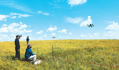
Researchers from the Satellite Application Center for Ecology and Environment under the Ministry of Ecology and Environment operate drones to collect data. (Photo courtesy of the interviewee)
"The system ensures greater efficiency and a wider scope in biodiversity surveys and monitoring, and is more sustainable," Gao said.
Gao added that the system can easily monitor plant groups and track the movements of large animals, making it very effective for biodiversity monitoring.
The development of this system took years.
Wan Huawei, director of SACEE's biodiversity remote sensing monitoring and assessment center, began relevant efforts over a decade ago. She and her team noticed news about smooth cordgrass, a non-native invasive plant, in Guangxi Zhuang Autonomous Region. In collaboration with a local team, they used high-resolution satellite and drone remote sensing methods to determine the plant's distribution and spread, providing technical support for managing the invasive species.

A model of a 3D ecological monitoring system involving a space-air-ground integrated network. (People's Daily Overseas Edition/Liu Fawei)
Several years ago, Wan collaborated with Lyu Zhi, a professor from Peking University, to monitor snow leopard habitats using high-resolution satellite remote sensing data.
By collecting detailed information about the land and human activities, along with existing ground surveys, researchers identified which areas are best for snow leopards and how these habitats are connected. This helped them plan better ways to monitor snow leopards and create ecological corridors.
Zhou Haili, deputy director of the SACEE, said that the launch of China's high-resolution Gaofen satellites and the development of advanced devices have provided important data for their integrated monitoring system. Better data processing technologies have also allowed them to monitor different species directly.
Additionally, ground monitoring tools like infrared cameras and drones with high-definition cameras allow researchers to study biodiversity in detail. They can look at species, communities, landscapes, and ecosystems from different angles, Zhou noted. This helps them better understand biodiversity and analyze medium- and long-term trends in key areas and communities.
For Wang Yongcai and his colleagues from the SACEE's biodiversity remote sensing monitoring and assessment center, the main tasks are to collect data, monitor grass species and growth conditions, and establish a basic grassland database in north China's Inner Mongolia Autonomous Region.
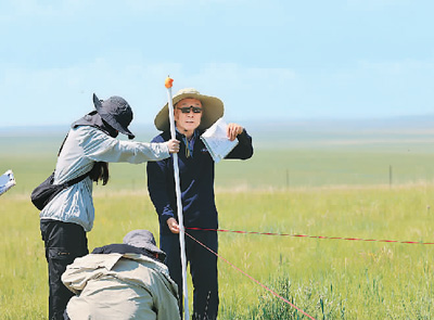
Researchers from the Satellite Application Center for Ecology and Environment under the Ministry of Ecology and Environment monitor biodiversity. (Photo courtesy of the interviewee)
The system allows them to continuously monitor grass growth, vegetation coverage, and issues like degradation, desertification, and salinization.
So far, they have gathered a lot of useful data and created a smart system to identify grassland plants and collect information about the grasslands remotely.
"Based on the existing database, the identification accuracy rate for more than half of the plant species in the pilot areas in Inner Mongolia has exceeded 80 percent," Wan said.
To expand the database, the SACEE plans to construct a drone airport. "We have finished the site selection. Once the airport is constructed, we can remotely control the takeoff and landing of drones from Beijing, which will significantly enhance our data collection capabilities," said Xiao Cui from the SACEE.
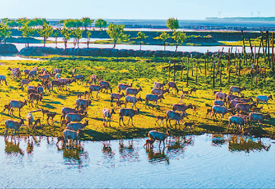
A herd of milu deer at a wetland in Dafeng district, Yancheng city, east China's Jiangsu Province. (People's Daily Online/Zhang Lianhua)
In recent years, the SACEE has continuously upgraded drones and developed new tools for biodiversity monitoring, including a multifunctional ecological monitoring vehicle independently developed by Gao's team in August 2022.
"The ecological monitoring vehicle has been successively deployed to Beijing, Inner Mongolia, Qinghai, Shandong, and other places for field experiments, and has achieved good results," said Cao Fei, head of the SACEE's ecological environment spatial data center.
New concepts and technologies are bringing more encouraging changes to biodiversity monitoring. "We hope to improve biodiversity monitoring through continuous efforts and contribute to the implementation of the Kunming-Montreal Global Biodiversity Framework," Zhou said.
Photos


Related Stories
- Technology gives ecological protection an edge in Hainan Tropical Rainforest National Park
- Researcher devoted to safeguarding ecosystem stability in China's Changbai Mountains
- Ecological conservation efforts yield fruitful outcomes in Qinghai, China
- Marine ecological pasture complex gains development momentum in E China
- Technology enhances ecological protection in China
- China establishes world's largest ecological monitoring network system: MEE
- Putian in SE China's Fujian promotes green development of marine fishery sector
Copyright © 2026 People's Daily Online. All Rights Reserved.
