
Jilin-1 satellite is launched on Oct. 7, 2015. (Photo/Xinhua)
China is speeding up its commercial use of remote sensing satellites, a key move to boost the industry, said Xu Wen, president of the China Center for Resources Satellite Data and Application, Science and Technology Daily reported on Jan. 2.
The country had already started building a remote sensing satellite industry by the end of last century. However, for many years the data provided by these satellites was not able to satisfy demand.
In 2008, the country built a satellite system focused on providing medium and low-resolution data, which was far from suitable for commercial use. Besides, the number of such satellites was too small for sustainable service, and the resolution was low, Xu said.
In 2010, China launched a special high-resolution Earth observation project, and now there are six high-resolution satellites in orbit for civilian use.
Nowadays, data sent back by remote sensing satellites are gaining customer recognition, and the market share of high-definition data has gradually risen to 85 percent in China, said Xu.
China has taken some steps in the development of commercial remote sensing satellites. In 2015, the first remote sensing satellite of the Jilin-1 satellite series was launched, with a plan to put 138 satellites into service by 2030, thereby increasing temporal resolution to ten-minute revisits.
Globally, remote sensing satellites accounted for less than one percent of the total application scale in 2017, with a net worth of about $260 billion, Xu said.
 Fire brigade in Shanghai holds group wedding
 Tourists enjoy ice sculptures in Datan Town, north China
 Sunset scenery of Dayan Pagoda in Xi'an
 Tourists have fun at scenic spot in Nanlong Town, NW China
 Harbin attracts tourists by making best use of ice in winter
 In pics: FIS Alpine Ski Women's World Cup Slalom
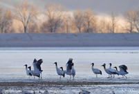 Black-necked cranes rest at reservoir in Lhunzhub County, Lhasa
 China's FAST telescope will be available to foreign scientists in April
 "She power" plays indispensable role in poverty alleviation
 Top 10 world news events of People's Daily in 2020
 Top 10 China news events of People's Daily in 2020
 Top 10 media buzzwords of 2020
 Year-ender:10 major tourism stories of 2020
 No interference in Venezuelan issues
 Biz prepares for trade spat
 Broadcasting Continent
 Australia wins Chinese CEOs as US loses