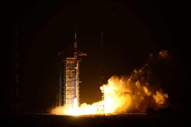
The Gaofen-5 satellite is launched off the back of a Long March 4C rocket from the Taiyuan Satellite Launch Center in Shanxi Province at 2:28 a.m. Beijing Time on Wednesday, May 9, 2018. [Photo: China Plus]
The traffic jams in Bangkok, Thailand's capital, are known to be some of the worst in the world. However, that could soon be a thing of the past, thanks to China’s Beidou Navigation System, as China sets out to develop a high-precision positioning system for the city, Chinanews.com reported recently.
China is working on a high-precision navigation tool for an intelligent transportation system in Bangkok, said Wu Yirong, director of the Aerospace Information Research Institute under the Chinese Academy of Sciences. He spoke at the China-ASEAN Forum on Building a “Belt and Road” Spatial Information Corridor, which was held on September 11, 2018, in Nanning, capital of south China’s Guangxi Zhuang Autonomous Region.
While at the forum, Wu Yanhua, vice director of China National Space Administration, revealed that China now has over 200 satellites in orbit, providing services in areas including communication, navigation, remote sensing, and space science.
China has signed more than 30 cooperative agreements with 15 Belt and Road countries and regions, and will strive to contribute “Chinese solutions” to ASEAN countries, added the vice director.
According to Wu, China will make efforts to promote the construction of infrastructure, public platform and industrial development of satellite application, and speed up international cooperation on the peaceful use of outer space, to provide support for the spatial information development of ASEAN countries.
China’s new generation geostationary orbit optical remote sensing satellite, Gaofen-4, can now provide ASEAN countries with disaster prevention and mitigation services, said the vice director.
He disclosed that the China-ASEAN Remote Sensing Satellite Data Sharing and Service Platform had already provided technical support for logistics management in Cambodia, agricultural and forestry management in Laos, and port management in Singapore.
Wu also pointed out that the data receiving and distribution system of China’s Fengyun series satellites has dramatically improved the comprehensive capabilities of many ASEAN countries in meteorological monitoring and disaster prevention.
"China has cutting edge satellite technology, and can provide off-the-shelf services in telecommunications, internet, industrial and agricultural production for ASEAN countries who don’t have satellites,” said Mr. Vincent Wong Wai Sang, CEO of the Malaysian Innovation Hub.
Wang divulged that Malaysia would carry out closer cooperation with China in the field of spatial information to meet the needs of ASEAN's economic development and benefit people in the region.
The assistant executive director of Thailand’s Geo-Informatics and Space Technology Development Agency is also looking forward to the cooperation with China. He said that Chinese satellites could provide accurate and comprehensive real-time data for Thailand, which will bring tangible benefits to their work in smart city construction, major project planning, as well as disaster prevention and mitigation.
 Fire brigade in Shanghai holds group wedding
 Tourists enjoy ice sculptures in Datan Town, north China
 Sunset scenery of Dayan Pagoda in Xi'an
 Tourists have fun at scenic spot in Nanlong Town, NW China
 Harbin attracts tourists by making best use of ice in winter
 In pics: FIS Alpine Ski Women's World Cup Slalom
 Black-necked cranes rest at reservoir in Lhunzhub County, Lhasa
 China's FAST telescope will be available to foreign scientists in April
 "She power" plays indispensable role in poverty alleviation
 Top 10 world news events of People's Daily in 2020
 Top 10 China news events of People's Daily in 2020
 Top 10 media buzzwords of 2020
 Year-ender:10 major tourism stories of 2020
 No interference in Venezuelan issues
 Biz prepares for trade spat
 Broadcasting Continent
 Australia wins Chinese CEOs as US loses