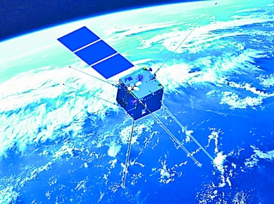
China’s first seismo-electromagnetic satellite Zhangheng 1 launched on Feb. 2 is a significant complementary to the country’s ability in the study of seismic precursors, said Shen Xuhui, chief scientist of the satellite.
“China is one of the world’s worst-hit areas for earthquakes, featuring wide distribution, high intensity, and shallow focal point,” Shen noted.
Ground monitoring stations used to be the major devices for China’s seismic surveillance. The incapability of such stations in Qinghai-Tibet Plateau and the marine regions restricted the development of the country’s seismic studies, Shen explained.
Research shows that earthquakes can trigger variation of electromagnetic information across the globe. With broad coverage, an excellent electromagnetic environment, and strong dynamic information, the seismo-electromagnetic satellite will greatly improve the understanding of seismic precursors.
“The satellite can achieve real-time transfer of high-energy particles data, such as electromagnetic fields and ionized stratum, offering researchers stable and continuous support by big data,” the chief scientist said.
It will help record global earthquake cases and make earthquake inspections more likely, he added.
 Fire brigade in Shanghai holds group wedding
 Tourists enjoy ice sculptures in Datan Town, north China
 Sunset scenery of Dayan Pagoda in Xi'an
 Tourists have fun at scenic spot in Nanlong Town, NW China
 Harbin attracts tourists by making best use of ice in winter
 In pics: FIS Alpine Ski Women's World Cup Slalom
 Black-necked cranes rest at reservoir in Lhunzhub County, Lhasa
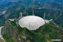 China's FAST telescope will be available to foreign scientists in April
 "She power" plays indispensable role in poverty alleviation
 Top 10 world news events of People's Daily in 2020
 Top 10 China news events of People's Daily in 2020
 Top 10 media buzzwords of 2020
 Year-ender:10 major tourism stories of 2020
 No interference in Venezuelan issues
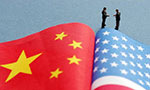 Biz prepares for trade spat
 Broadcasting Continent
 Australia wins Chinese CEOs as US loses