(Photo/Yangzhou Daily)
China is now capable of deploying domestically-designed drones to the waters around Diaoyu Island and the South China Sea for surveying and mapping, an industry expert revealed on Sept. 20.
Addressing the 6th China International UAS Conference (International UAS China 2016), Li Yingcheng, general manager of China TopRS Technology Co. Ltd., affiliated with the Chinese Academy of Surveying & Mapping, noted that Chinese drones can fully cover waters 80 nautical miles from the coastline. They can also partially cover open sea up to 1,500 nautical miles from the coastline.
China has a total of 12,186 islands and reefs scattered across a total area of 3 million square kilometers. Many are located up to 1,000 kilometers away from the mainland. Some 27.5 percent have an area of less than 500 square meters. In addition, many of the islands and reefs in the South China Sea have much larger underwater portions than what is visible above water, making them harder to survey and map, according to Li.
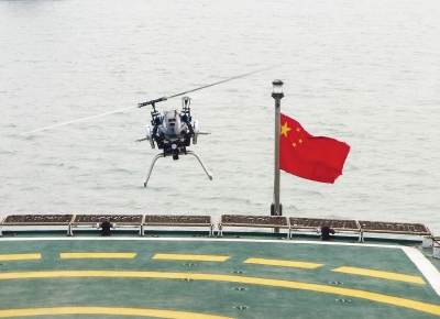
In response to this challenge, China has designed drones to handle such complicated surveying, including the ZC-5B and Zc-10 unmanned aircraft systems (UAS). The ZC-5B has a maximum flight distance of 1,400 kilometers, and can stay in the air for up to 30 consecutive hours. Its design makes it especially stealthy, which comes in handy for open sea reef surveying and mapping, Li said.
The Zc-10 has a maximum load of 16 kilograms and can fly for more than six hours. Its aerial survey CCD camera weighs just 1.5 kilograms and boasts 80 million pixels; the drone’s position and orientation system weighs merely 520 grams. Using the Beidou navigation system, drones can be controlled and monitored during open sea reef surveying and mapping.
“Reefs and islands are an important parts of our national territory. Precise information of their geology is crucial evidence for the demarcation of territorial waters and for safeguarding national maritime interests and security,” Li said, pointing out that it’s difficult for satellites to collect high-definition photos of small reefs.
“In the future, we hope to avoid standing out in the sun and doing such toilsome labor during inspection trips,” said Su Fenzhen, director of the State Key Laboratory of Resources and Environmental Information Systems. Su is also a researcher at the Geographic Sciences and Natural Resources Institute under the Chinese Academy of Sciences, who has conducted field studies on reefs in the South China Sea.
Based on his experience, Su noted that reefs are sometimes hard to approach, as large reef bases can potentially strand ships, making surveying the region arduous. “But drones can help with temporary protection … or facilities inspection and mapping [of the reefs],” he added.
Thanks to such technology, China captured its first set of aerial photographs of Diaoyu Island in June 2009, with a resolution ratio of 0.1 meters. In 2012, China began surveying and mapping Diaoyu Island. The third mapping mission was conducted in July 2014. It has now become a regulatory surveying mission, Li said.
Chinese drones also flew to Yongxing and Dong in the Xisha Islands in May 2011. The nine-hour trip marked the first surveying and mapping mission carried out by drones. In May 2014, another drone flight was conducted in Qilian Yu in the Xisha Islands. The results of that flight showed 10 reefs above water in Qilian Yu, Li said.

(Su Fenzhen presents a photo taken at South China Sea. Photo/Jiang Jie)
 Fire brigade in Shanghai holds group wedding
 Tourists enjoy ice sculptures in Datan Town, north China
 Sunset scenery of Dayan Pagoda in Xi'an
 Tourists have fun at scenic spot in Nanlong Town, NW China
 Harbin attracts tourists by making best use of ice in winter
 In pics: FIS Alpine Ski Women's World Cup Slalom
 Black-necked cranes rest at reservoir in Lhunzhub County, Lhasa
 China's FAST telescope will be available to foreign scientists in April
 "She power" plays indispensable role in poverty alleviation
 Top 10 world news events of People's Daily in 2020
 Top 10 China news events of People's Daily in 2020
 Top 10 media buzzwords of 2020
 Year-ender:10 major tourism stories of 2020
 No interference in Venezuelan issues
 Biz prepares for trade spat
 Broadcasting Continent
 Australia wins Chinese CEOs as US loses