LANZHOU, March 21 (Xinhua) -- Researchers have developed a new method to evaluate and predict potential landslides.
Landslides can result in serious impacts. There is a continuing need to develop better tools to enhance the effectiveness of landslide risk assessment and management.
Researchers from China's Lanzhou University combined empirical modeling with time-series Interferometric Synthetic Aperture Radar (InSAR) techniques to assess potential landslide locations, areas and volumes at the Heitai river terraces of the Yellow River in northwest China's Gansu Province.
The elevated terrace has a substantial aeolian loess deposition. Many landslides have been triggered along the terrace edges due to gradually rising of groundwater levels following continuous irrigation since 1968.
The researchers proposed the new method to predict the location, area and volume of the potential landslides. According to Meng Xingmin, a leading researcher of the study, employing the combination approach of the empirical model, InSAR techniques and field survey is of significance to construct a map that can show the magnitudes and activities of potential landslides.
The research is expected to provide significant further scientific insights to inform landslide hazard and risk management. It can also be applied to many other parts of China's Loess Plateau or similar areas across the world.
 Fire brigade in Shanghai holds group wedding
 Tourists enjoy ice sculptures in Datan Town, north China
 Sunset scenery of Dayan Pagoda in Xi'an
 Tourists have fun at scenic spot in Nanlong Town, NW China
 Harbin attracts tourists by making best use of ice in winter
 In pics: FIS Alpine Ski Women's World Cup Slalom
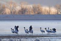 Black-necked cranes rest at reservoir in Lhunzhub County, Lhasa
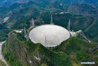 China's FAST telescope will be available to foreign scientists in April
 "She power" plays indispensable role in poverty alleviation
 Top 10 world news events of People's Daily in 2020
 Top 10 China news events of People's Daily in 2020
 Top 10 media buzzwords of 2020
 Year-ender:10 major tourism stories of 2020
 No interference in Venezuelan issues
 Biz prepares for trade spat
 Broadcasting Continent
 Australia wins Chinese CEOs as US loses