Fri,Dec 26,2014
 Old photos of Chinese President Xi Jinping’s father and his families
 Bikini show in 2014 China Final of Miss Tourism World
 Close-up view of August Aerobatic Team
 Goddesses married in 2014
 Polar region photos raise worldwide awareness of global warming
 Get off at the last stop — Beijing Subway in vision
 Top 100 beauties in the world!
 Gallery: Who is the most beautiful one?
 If you like autumn, put your hands in the air!
 Fan Bingbing's "Queen style" in new play
BEIJING, Dec. 26 -- China can now view the entire country's land mass using HD satellite images, it was announced at a national geo-mapping conference held on Friday.
According to a statement issued by the National Administration of Surveying, Mapping and Geoinformation, China began capturing remote-sensing images with clear view of objects of a meter in length or smaller since 2012.
By October 2014, such high-resolution images had covered China's entire land territory.
Meanwhile, China's cities are being upgraded to smart cities or digital cities.
 Tempting Yunnan cuisine
 Joint anti-piracy drill
 Time travel photos become a hit in military academies
 Beautiful Chinese woman
 Chestnut girl goes viral online
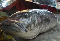 Unknown 'monster' fish caught in Shandong
 20 years on: Relocated Three Gorges residents through lens
 PLA HK Garrison veterans leave behind beautiful smiles
 Victoria's Secret Fashion Show
 Robot restaurants
 Chubby children
 The Interview a hit in China
 Long-term view needed to judge Mao fairly
Day|Week|Month