Thousands of tourists and astronomy enthusiasts flocked to Indonesia to catch the country's first solar eclipse in nearly 33 years - but Nasa has revealed an even more spectacular view.
The Deep Space Climate Observatory (DSCOVR) captured 13 stunning images capturing the shadow of the Moon marching across Earth's sunlit face.
They then turned this into a stunning animation to give a unique glimpse.
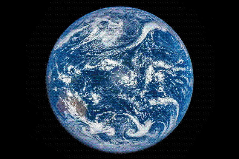
The Deep Space Climate Observatory (DSCOVR) captured 13 stunning images capturing the shadow of the Moon marching across Earth's sunlit face. In this, the only total solar eclipse of 2016, the shadow of the new Moon starts crossing the Indian Ocean and marches past Indonesia and Australia into the open waters and islands of Oceania (Melanesia, Micronesia, and Polynesia) and the Pacific Ocean.
The animation above was assembled from 13 images acquired on March 9, 2016, by NASA's Earth Polychromatic Imaging Camera (EPIC), a four-megapixel charge-coupled device (CCD) and Cassegrain telescope on the DSCOVR satellite.
'What is unique for us is that being near the Sun-Earth line, we follow the complete passage of the lunar shadow from one edge of the Earth to the other,' said Adam Szabo, NASA's project scientist for DSCOVR.
'A geosynchronous satellite would have to be lucky to have the middle of an eclipse at noon local time for it. I am not aware of anybody ever capturing the full eclipse in one set of images or video.'
In the images, the shadow of the new Moon starts crossing the Indian Ocean and marches past Indonesia and Australia into the open waters and islands of Oceania (Melanesia, Micronesia, and Polynesia) and the Pacific Ocean. Note how the shadow moves in the same direction as Earth rotates.
The bright spot in the center of each disk is sunglint—the reflection of sunlight directly back at the EPIC camera.
From its position about 1.6 million kilometers (1 million miles) from Earth and toward the Sun, DSCOVR maintains a constant view of the sunlit face of the planet.
EPIC acquires images using ten different spectral filters—from ultraviolet to near infrared—to produce a variety of science products.
Natural-color images are generated by combining three separate monochrome exposures (red, green, and blue channels) taken in quick succession.
According to Szabo, the satellite normally collects images at all ten wavelengths about once every 108 minutes (with just one image at full resolution).
For this eclipse, the EPIC team collected full-resolution images every 20 minutes on just the red, green, and blue channels.
This allowed the satellite to collect 13 images spanning the entire four hours and twenty minutes of the eclipse.
In addition to the EPIC camera, DSCOVR carries the National Institute of Standards and Technology Advanced Radiometer (NISTAR), an instrument that measures how much solar energy is being radiated back into space from Earth.
In coming weeks, scientists will be analyzing NISTAR data to quantify how the eclipse changed the incoming and outgoing radiation for those few hours.
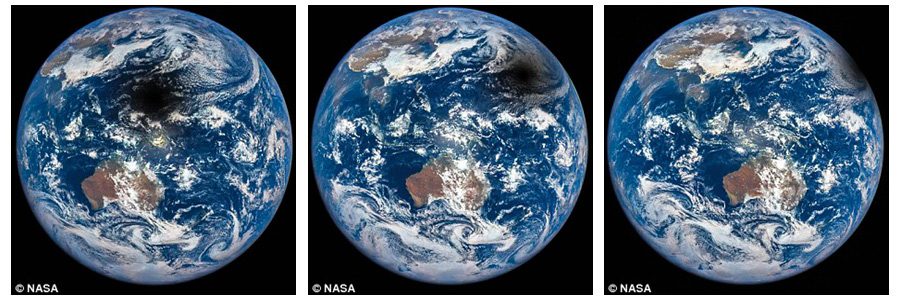
The shadow of the new Moon starts crossing the Indian Ocean and marches past Indonesia and Australia into the open waters and islands of Oceania (Melanesia, Micronesia, and Polynesia) and the Pacific Ocean.
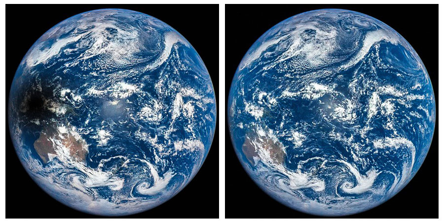
The bright spot in the center of each disk is sunglint—the reflection of sunlight directly back at the EPIC camera.
On Earth, the eclipse was also visible in parts of Australia and south-east Asia.
However, only some parts of the country got to see the sun totally eclipsed by the moon, which happened almost immediately after the sun rose.
Because the moon's shadow crossed the international date line, it appeared in the afternoon of the 8th in some regions, despite being visible from the morning of the 9th in others.
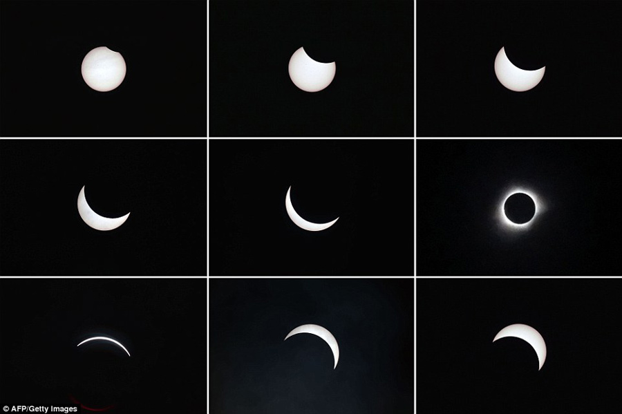
This combined photo shows the moon passing in front of the sun (top left to bottom right) during a total solar eclipse in the city of Ternate, in Indonesia's Maluku Islands, on March 9.

A partial solar eclipse is pictured above a cloud formation at dawn in Singapore on March 9. The eclipse was also visible around the region in Indonesia and Malaysia. However, only some parts of the country got to see the sun totally eclipsed by the moon, which happened almost immediately after the sun rose.
A solar eclipse happens when the moon casts a shadow on the earth as it passes between the earth and the sun.
At least twice a year, the orbits of the moon and Earth block the sun to cause a shadow on Earth.
Most eclipses are partial, but when the moon is in close to the earth, it results in a total eclipse.
The last total solar eclipse was in March 2015, and the one before that was in November 2012.
The total eclipse was visible within a roughly 62 to 93-mile (100-150km) wide path that started in the Indian Ocean and sliced across parts of Indonesia including Sumatra, Kalimantan and Sulawesi before ending in the northern Pacific Ocean.

Day|Week

 Beijing steps up security for 'two sessions'
 Chongqing sniper’s new record: 13 holes on a rice grain
 Women put on spring dresses in Hangzhou
 UAVs at Unmanned Systems Exhibition & Conference in UAE
 PLA's paratroopers conduct night training
 Three new-type tank landing ships join the East China Sea Fleet
 3,492 reflector panels of China's mega telescope installed
 Stunning Kuche on the Silk Road
 Tunisian man creates art of sand in Hangzhou
 Goddess teacher shares fitness program online

