Not long ago, our best image of Pluto was of a blurry, blob that orbited on the edge of our solar system.
But since New Horizon's flyby of the dwarf planet, astronomers have gained an unprecedented insight into its varied terrain, which includes vast plains, parallel blades known as 'snakeskin terrain,' and ice volcanoes.
Now, to help understand the diversity of its features and to piece together how Pluto's surface has evolved, scientists have put together a stunning geological map of its surface.
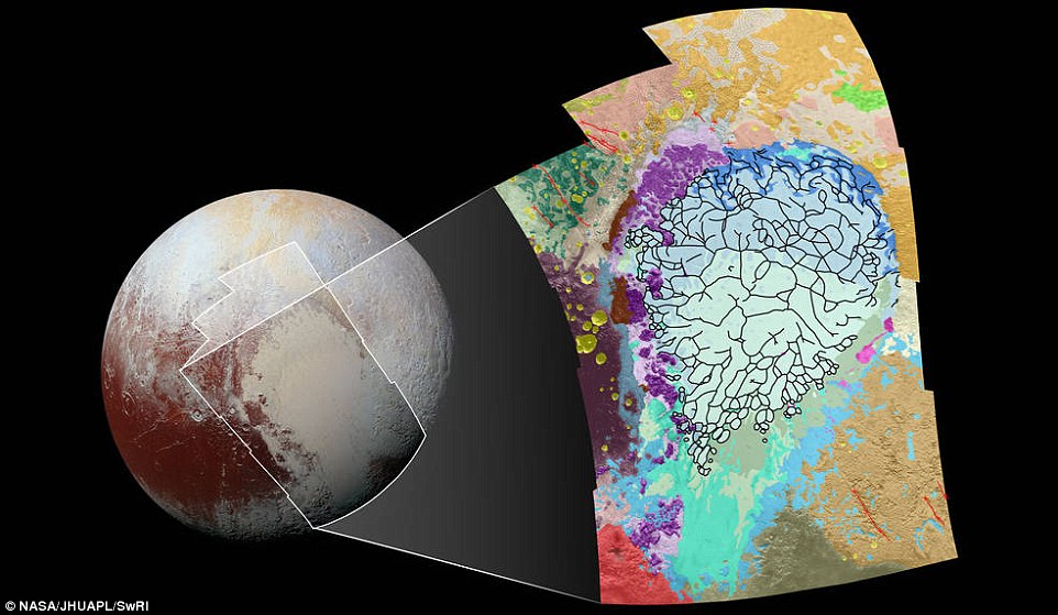
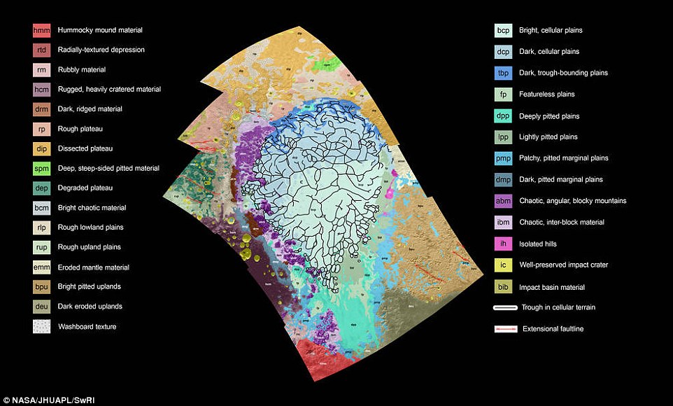
This map covers a portion of Pluto's surface that measures 1,290 miles (2,070km) from top to bottom, and includes the vast nitrogen-ice plain informally named Sputnik Planum and surrounding terrain. The map is overlaid with colors that represent different geological terrains. Each terrain, or unit, is defined by its texture and morphology – smooth, pitted, craggy, hummocky or ridged, for example
This map covers a portion of Pluto's surface that measures 1,290 miles (2,070km) from top to bottom, and includes the vast nitrogen-ice plain informally named Sputnik Planum and surrounding terrain.
It is part of a heart-shaped feature, informally named 'Tombaugh Regio' (Tombaugh Region) after Clyde Tombaugh, who discovered Pluto in 1930.
As the key in the figure indicates, the map is overlaid with colours that represent different geological terrains.
Each terrain, or unit, is defined by its texture and morphology – smooth, pitted, craggy, hummocky or ridged, for example.
How well a unit can be defined depends on the resolution of the images that cover it.
All of the terrain in this map has been imaged at a resolution of approximately 1,050ft (320 meters) per pixel or better, meaning scientists can map units with relative confidence.
The various blue and greenish units that fill the center of the map represent different textures seen across Sputnik Planum, from the cellular terrain in the center and north, to the smooth and pitted plains in the south.
The blue and greenish units represent different textures seen across Sputnik Planum, from the cellular terrain in the center and north, to the smooth and pitted plains in the south. The black lines represent troughs that mark the boundaries of cellular regions in the nitrogen ice. Purple represents the chaotic mountain ranges that line Sputnik's western border, and the pink, floating hills at its eastern edge
The black lines represent troughs that mark the boundaries of cellular regions in the nitrogen ice.
The purple unit represents the chaotic, blocky mountain ranges that line Sputnik's western border, and the pink unit represents the scattered, floating hills at its eastern edge.
The possible cryovolcanic feature informally named Wright Mons is mapped in red in the southern corner of the map.
The rugged highlands of the informally named Cthulhu Regio are mapped in dark brown along the western edge, pockmarked by many large impact craters, shown in yellow.
By studying how the boundaries between units crosscut one another, mission scientists can determine which units overlie others, and assemble a relative chronology for the different units.
For example, the yellow craters (at left, on the western edge of the map) must have formed after their surrounding terrain.
Producing such maps is important for gauging what processes have operated where on Pluto, and when they occurred relative to other processes at work.
The base map for this geologic map is a mosaic of 12 images obtained by the Long Range Reconnaissance Imager (LORRI) at a resolution of 1,280 feet (about 390 meters) per pixel.
The mosaic was obtained at a range of approximately 48,000 miles (77,300km) from Pluto, about an hour and 40 minutes before New Horizons' closest approach on July 14, 2015.
Pluto's terrain may be even more complex than thought. Earlier this month, scientists said that hills of water ice could be 'floating' in a sea of frozen nitrogen on Pluto, moving over time like icebergs in Earth's Arctic Ocean
 |
Day|Week

 China releases HD true color images of lunar surface
 To-be flight attendants undergo training at snow-covered field
 Aerial photos taken on J-11 fighter
 'Coldest town in China' — a fairyland you don't want to miss
 Deep love for breathtaking Hainan
 Beautiful Chinese tennis player Wang Qiang goes viral online
 Minus 71 degrees! Coldest village on earth
 Chinese pole dancing master opens class in Tianjin
 The most beautiful town of snow in China
 SWAT members hold romantic wedding in E China

