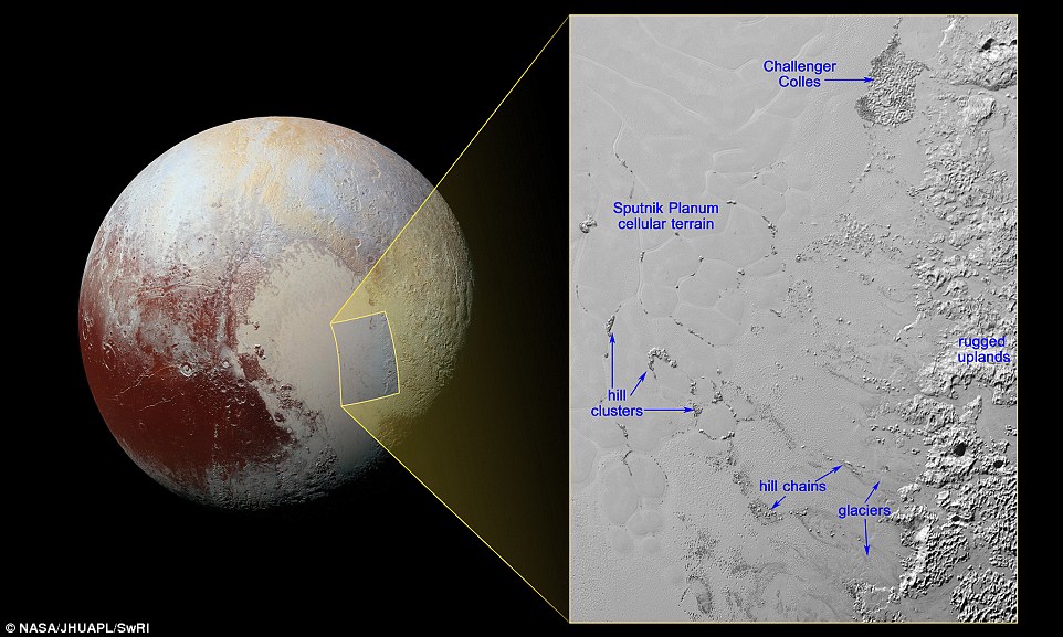
Hills of water ice on Pluto 'float' in a sea of frozen nitrogen and move over time like icebergs in Earth's Arctic Ocean. This shows the inset in context next to a larger view. The resolution is about 1050ft (320 meters) per pixel and 300 miles (almost 500km) long and 210 miles (340km) wide. It was taken 9,950 miles (16,000km) from Pluto, 12 minutes before New Horizons' closest approach to Pluto on July 14
These hills, which can be seen in the latest images studied by the New Horizons team, are believed to measure one to several miles across.
They are found in the vast ice plain informally named Sputnik Planum within Pluto's 'heart' and are likely miniature versions of the larger, jumbled mountains on the region's western border.
Their discovery follows news last week that Pluto may be covered in a lot more water ice than astronomers previously thought, which could boost the chances for finding a liquid sea and alien life.
Nasa describes the feature as 'yet another example of Pluto's fascinating and abundant geological activity.'
Because water ice is less dense than nitrogen-dominated ice, scientists believe these water ice hills are floating in a sea of frozen nitrogen and move over time like icebergs on Earth.
The hills may be fragments of the rugged uplands that have broken away and are being carried by the nitrogen glaciers into Sputnik Planum.
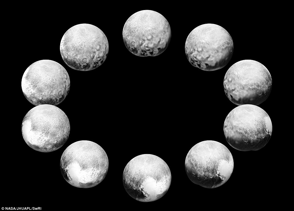
This image depicts an entire day on the dwarf planet. The space agency released a series of 10 close-ups of the frosty, faraway world today, representing one Pluto day, which is equivalent to 6.4 Earth days. The New Horizons spacecraft took the pictures as it zoomed past Pluto in an unprecedented flyby in July. Pluto was between 400,000 and 5 million miles from the camera for these photos
'Chains' of the drifting hills are formed along the flow paths of the glaciers.
When the hills enter the cellular terrain of central Sputnik Planum, they become subject to the motions of the nitrogen ice, and are pushed to the edges of the cells, where the hills cluster in groups reaching up to 12 miles (20km) across.
At the northern end of the image, the feature informally named Challenger Colles – honouring the crew of the lost space shuttle Challenger – appears to be an especially large accumulation of these hills, measuring 37 by 22 miles (60 by 35km).
This feature is located near the boundary with the uplands, away from the cellular terrain, and may represent a location where hills have been 'beached' due to the nitrogen ice being especially shallow.
The more detailed map reveals the spread of water ice across much of Pluto, much more than previously known.
Some regions on the map, including Sputnik Planum, the western region of Pluto's 'heart,' and Lowell Regio in the north, were observed to exhibit little evidence of water, if any at all.
This suggests that the bedrock in these areas is buried beneath an accumulation of other ices, such as methane, nitrogen, and carbon monoxide.
 |  |
Day|Week

 China releases HD true color images of lunar surface
 To-be flight attendants undergo training at snow-covered field
 Aerial photos taken on J-11 fighter
 'Coldest town in China' — a fairyland you don't want to miss
 Deep love for breathtaking Hainan
 Beautiful Chinese tennis player Wang Qiang goes viral online
 Minus 71 degrees! Coldest village on earth
 Chinese pole dancing master opens class in Tianjin
 The most beautiful town of snow in China
 SWAT members hold romantic wedding in E China

