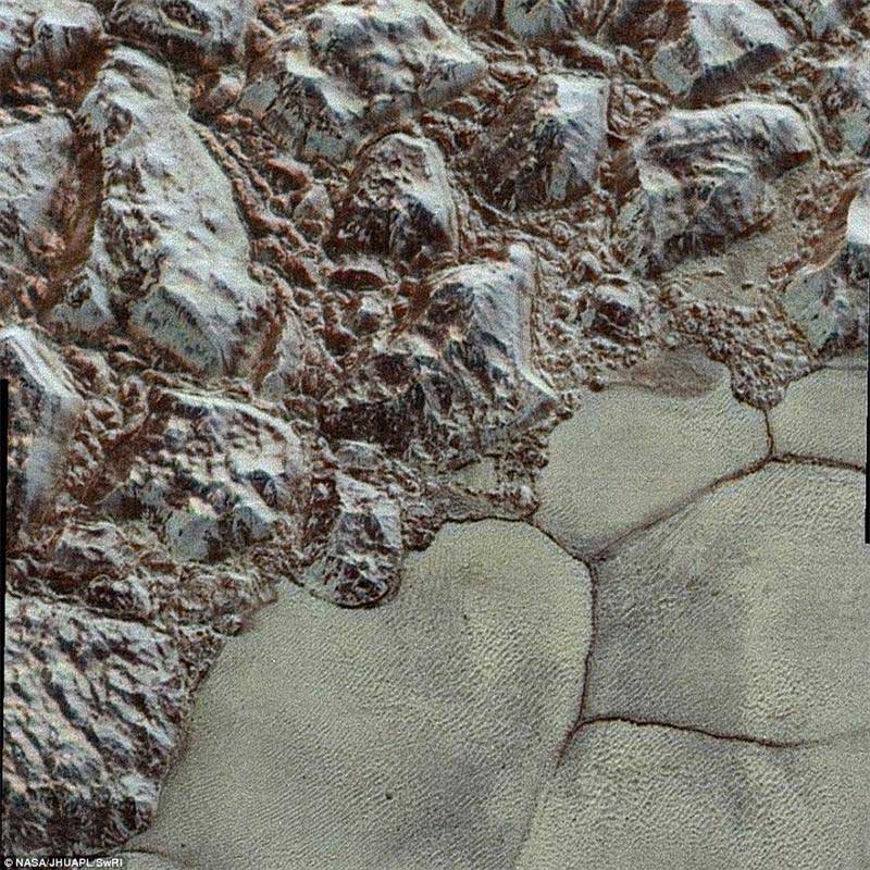
Pictured here is the mountainous shoreline of Sputnik Planum. In this highest-resolution image from New Horizons, great blocks of Pluto's water-ice crust appear jammed together in the informally named al-Idrisi mountains. 'The mountains bordering Sputnik Planum are absolutely stunning at this resolution,' said New Horizons science team member John Spencer of the Southwest Research Institute
Nasa also revealed a new colourised version of the surface.
This enhanced color mosaic combines some of the sharpest views of Pluto that NASA's New Horizons spacecraft obtained during its July 14 flyby.
The pictures are part of a sequence taken near New Horizons' closest approach to Pluto, with resolutions of about 250-280 feet (77-85 meters) per pixel – revealing features smaller than half a city block on Pluto's surface.
Lower resolution color data (at about 2,066 feet, or 630 meters, per pixel) were added to create this new image.
The images form a strip 50 miles (80 kilometers) wide, trending (top to bottom) from the edge of 'badlands' northwest of the informally named Sputnik Planum, across the al-Idrisi mountains, onto the shoreline of Pluto's 'heart' feature, and just into its icy plains.
They combine pictures from the telescopic Long Range Reconnaissance Imager (LORRI) taken approximately 15 minutes before New Horizons' closest approach to Pluto, with – from a range of only 10,000 miles (17,000 kilometers) – with color data (in near-infrared, red and blue) gathered by the Ralph/Multispectral Visible Imaging Camera (MVIC) 25 minutes before the LORRI pictures.
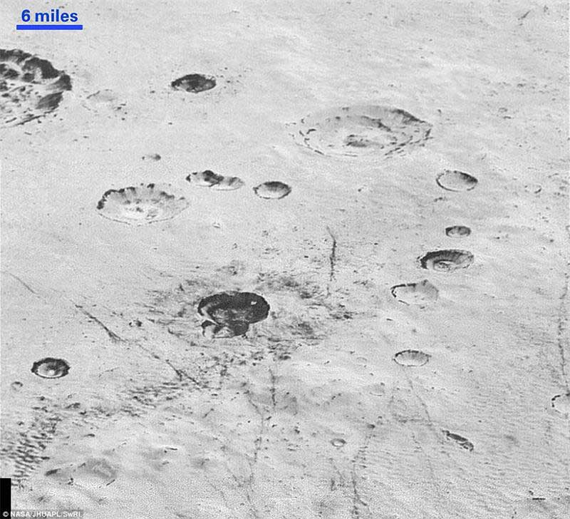
This image reveals new details of Pluto's rugged, icy cratered plains, including layering in the interior walls of many craters. 'Impact craters are nature's drill rigs, and the new, highest-resolution pictures of the bigger craters seem to show that Pluto's icy crust, at least in places, is distinctly layered,' said William McKinnon, deputy lead of the New Horizons Geology, Geophysics and Imaging team
'The wide variety of cratered, mountainous and glacial terrains seen here gives scientists and the public alike a breathtaking, super-high-resolution color window into Pluto's geology,' Nasa said.
From its rugged 'badlands' to its mountainous shorelines, the latest pictures are part of a sequence taken 15 minutes before New Horizons' closest approach on July 14.
The science we can do with these images is simply unbelievable
The resolution is stunning. At around 80 metres per pixel, incredible details can be picked out, such as huge ice blocks, dramatic craters and crumpled ridges - all less than half the size of a city block on Pluto's diverse surface.
'These close-up images, showing the diversity of terrain on Pluto, demonstrate the power of our robotic planetary explorers to return intriguing data to scientists back here on planet Earth,' said John Grunsfeld, former astronaut and associate administrator for Nasa's Science Mission Directorate.
'New Horizons thrilled us during the July flyby with the first close images of Pluto, and as the spacecraft transmits the treasure trove of images in its onboard memory back to us, we continue to be amazed by what we see.'
These latest images form a strip 50 miles (80 km) wide on a world three billion miles away.
The pictures trend from Pluto's jagged horizon about 500 miles (800 km) northwest of the informally named Sputnik Planum, across the al-Idrisi mountains, over the shoreline of Sputnik, and across its icy plains.
'These new images give us a breathtaking, super-high resolution window into Pluto's geology,' said New Horizons Principal Investigator Alan Stern, of the Southwest Research Institute (SwRI) in Boulder, Colorado.
'Nothing of this quality was available for Venus or Mars until decades after their first flybys; yet at Pluto we're there already – down among the craters, mountains and ice fields – less than five months after flyby. The science we can do with these images is simply unbelievable.'
The images were captured with the telescopic Long Range Reconnaissance Imager (LORRI) aboard New Horizons, about 15 minutes before New Horizons' closest approach to Pluto – from a range of just 10,000 miles (17,000 km).
They were obtained with an unusual observing mode; instead of working in the usual 'point and shoot,' LORRI snapped pictures every three seconds while the Ralph/Multispectral Visual Imaging Camera (MVIC) aboard New Horizons was scanning the surface.
This mode requires unusually short exposures to avoid blurring the images.
These new images are six times better than the resolution of the global Pluto map New Horizons obtained, and five times better than the best images of Pluto's cousin Triton, Neptune's large moon, obtained by Voyager 2 in 1989.
Mission scientists expect more imagery from this set over the next several days, showing even more terrain at this highest resolution.
It follows an image released by Nasa last month showing 10 close-ups of the frosty, faraway world today, representing one Pluto day, which is equivalent to 6.4 Earth days.
 |  |
Day|Week

 'Coldest town in China' — a fairyland you don't want to miss
 Deep love for breathtaking Hainan
 Beautiful Chinese tennis player Wang Qiang goes viral online
 Minus 71 degrees! Coldest village on earth
 Chinese pole dancing master opens class in Tianjin
 The most beautiful town of snow in China
 SWAT members hold romantic wedding in E China
 Breathtaking scenery and simple lifestyle in Hainan
 Finding sexiest underwear supermodels
 Top 10 ancient pagodas in China

