
Scientists from NASA’s New Horizons mission have also combined data from two instruments to create this composite image of Pluto’s informally named Viking Terra area.
Nasa also revealed new images of Pluto’s informally named Viking Terra area.
The combined data includes pictures taken by the spacecraft’s Long Range Reconnaissance Imager (LORRI) on July 14, 2015, from a range of about 31,000 miles (49,000 kilometers), showing features as small as 1,600 feet (480 meters) across.
Draped over the LORRI mosaic is enhanced color data from the Ralph/Multispectral Visible Imaging Camera (MVIC), gathered about 20 minutes after the LORRI snapshots were taken, from a range of 21,000 miles (34,000 kilometers) and at a resolution of about 2,100 feet (650 meters) per pixel.
The entire scene is 160 miles (250 kilometers) across.
Among the features scientists find particularly interesting are the bright methane ices that condensed on many crater rims; the collection of dark red tholins (small soot-like particles generated from reactions involving methane and nitrogen in the atmosphere) in low areas, like the bottoms of craters; and the layering on the faces of steep cliffs and on crater walls.
In areas where the reddish material is thickest and the surface appears smooth, the material seems to have flowed into some channels and craters. Scientists say tholin deposits of that thickness aren’t usually mobile on large scales, suggesting that they might be riding along with ice flowing underneath, or being blown around by Pluto’s winds.
The images are the latest to show mysterious 'pits' on the 'heart' of Pluto have been revealed in unprecedented detail, along with colour images of the dwarf planet's 'badlands'.
Mission scientists believe these mysterious indentations may form through a combination of ice fracturing and evaporation.
The scarcity of overlying impact craters in this area also leads scientists to conclude that these pits – typically hundreds of yards across and tens of yards deep – formed relatively recently.
Their alignment provides clues about the ice flow and the exchange of nitrogen and other volatile materials between the surface and the atmosphere.
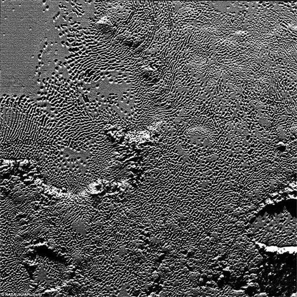
On July 14 the telescopic camera on NASA's New Horizons spacecraft took the highest resolution images ever obtained of the intricate pattern of 'pits' across a section of Pluto's prominent heart-shaped region, informally named Tombaugh Regio. The image is part of a sequence taken by New Horizons' Long Range Reconnaissance Imager (LORRI) as the spacecraft passed within 9,550 miles (15,400 kilometers) of Pluto's surface, just 13 minutes before the time of closest approach.
The image is part of a sequence taken by New Horizons' Long Range Reconnaissance Imager (LORRI) as the spacecraft passed within 9,550 miles (15,400 kilometers) of Pluto's surface, just 13 minutes before the time of closest approach.
The magnified view is 50-by-50 miles (80-by-80 kilometers) across.
The large ring-like structure near the bottom right of the magnified view - and the smaller one near the bottom left - may be remnant craters.
The upper-left quadrant of the image shows the border between the relatively smooth Sputnik Planum ice sheet and the pitted area, with a series of hills forming slightly inside this unusual 'shoreline.'
 |  |
Day|Week

 'Coldest town in China' — a fairyland you don't want to miss
 Deep love for breathtaking Hainan
 Beautiful Chinese tennis player Wang Qiang goes viral online
 Minus 71 degrees! Coldest village on earth
 Chinese pole dancing master opens class in Tianjin
 The most beautiful town of snow in China
 SWAT members hold romantic wedding in E China
 Breathtaking scenery and simple lifestyle in Hainan
 Finding sexiest underwear supermodels
 Top 10 ancient pagodas in China

