Tue,Sep 30,2014
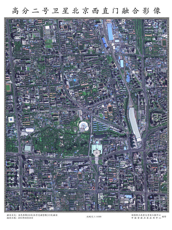 |
| The fusion image captured by Gaofen-2 shows Beijing's Xizhimen transport hub. [Photo: sastind.gov.cn] |
Chinese space authorities have publicized the first batch of photos captured by Gaofen-2, the country's most advanced Earth observation satellite so far. CRI's Qizhi has more.
A total of 15 high-resolution photos have been sent back by Gaofen-2, which was launched in August.
The photos include images of downtown Beijing and the bund area in Shanghai.
Gaofen-2 can capture the image of a meter-long object from space in full color.
This allows for much sharper pictures, and images strong enough to determine the type of a vehicles driving down the roads and images of pedestrians crossing the street.
The State Administration of Science, Technology and Industry for National Defense says it plans to use the new satellite to help with a variety of tasks, including land use surveillance, mineral resource surveys and disaster relief.
Xu Wen is a satellite expert with the China Aerospace Science and Technology Corporation.
He says engineers can use Gaofen-2 to calculate the height of buildings.
"The height of the highest building in Shanghai's Lujiazui District is about 600 meters. We can see its projection is longer than that of the Oriental Pearl TV Tower. We can measure and calculate the height of buildings via the length of their projection in the photos. Then we can judge the construction progress."
Different sensors carried on the satellite can also monitor crop growth, soil moisture and other things related to agriculture.
Chen Zhongxin is a researcher with the Chinese Academy of Agricultural Sciences.
"We can integrate the satellite data with our agriculture knowledge and professional models to extract professional agricultural data and provide real-time information to ordinary farmers and farms. Now that we are able to do this technically, we should be able to provide real-time services in about five years."
Xu Dazhe, head of China's National Space Administration, says Gaofen-2 and its predecessor, Gaofen-1, boast different advantages and the combined use of them will only create more benefits.
"Gaofen-1 and Gaofen-2 are different in terms of resolution as well as observation scope and method. The latter is good at observing target in a flexible manner due to its swing capabilities. I believe the cooperation of the two satellites will bring more detailed data for users. "
Gaofen-2 is the second of seven satellites to be launched as part of China's indigenous high-definition observation project.
The overall Gaofen project is expected to be operational by 2020.
For CRI, I'm Qizhi.
 |  |

 Chinese netizens fall in love with champion swimmer Ning Zetao
 East China Navy Fleet conducts drill in S China Sea
 Lingerie show at 2014 Miss China
 'Girlfriend' of Harry Potter visits Chengdu
 China's Pingyao Ancient Town
 Standard faces for each countries
 Being with you
 Legendary Chinese women in the early 20th century
 Leading director Wang Quan'an detained for 'buying sex'
 Top 10 Chinese actresses with pretty face
Day|Week|Month


