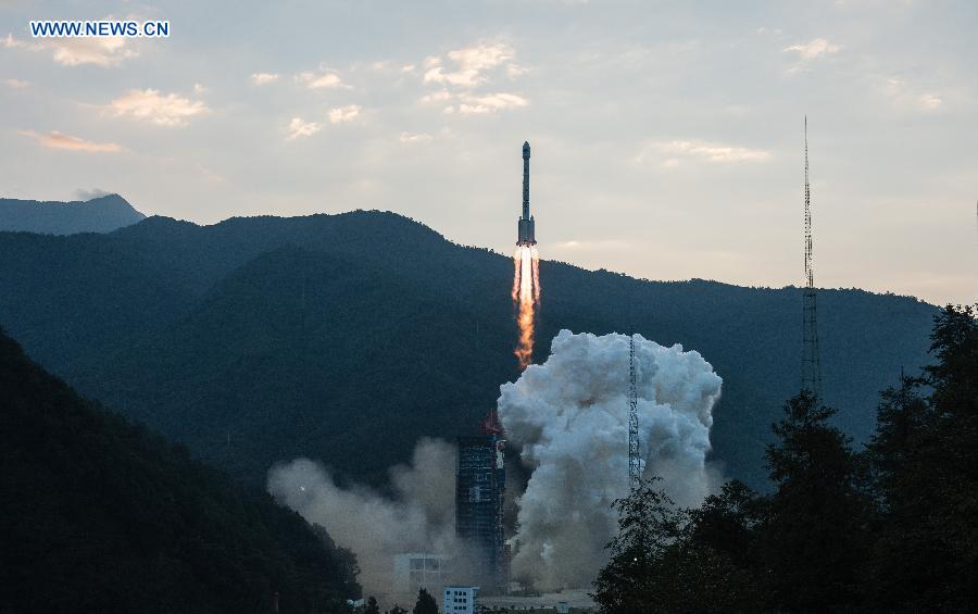
A Long March-3B carrier rocket carrying a new-generation Beidou satellite lifts off from the Xichang Satellite Launch Center in Xichang, southwest China's Sichuan Province, Sept. 30, 2015. China sent a new-generation satellite into orbit that will support its global navigation and positioning network at 7:13 a.m. Beijing Time Wednesday (2313 GMT Tuesday). It was the 20th satellite for the Beidou Navigation Satellite System (BDS), and put China one step closer to providing an alternative to the U.S.-operated GPS. [Photo: Xinhua]
Today marks China's first-ever "Space Day." It's also the 46th anniversary of the successful launch of the country's first satellite, 'Dong Fang Hong' or 'The East is Red.'
The country's aerospace industry has become a high-tech sector with strategic significance.
Three new-generation BeiDou navigation satellites were launched last year, and 98 percent of the components were Chinese made.
BeiDou Navigation Satellite System has been in operation since 2000, making China the third country with an autonomous nav-sat system after the United States and Russia.
China Aerospace Science and Technology Corporation is the main contractor for the country's space program. It undertakes a number of missions, including the design and manufacturing of key components of BeiDou.
Zhang Chuxian is a technical director at the institute.
"First of all, the BeiDou Navigation Satellite System has high-level technology indicators and also requires high-standard components. We need to develop better products, more advanced than those imported from abroad, to meet BeiDou's requirements. On the other hand, the development timescale is very tight, almost cut in half compared with before. Within that time we also need to have everything tested and verified. That means we need to develop better products with less time and more challenges."
China began building its BeiDou Navigation Satellite System 20 years after the GPS navigation system designed by the U.S.
The positioning accuracy of the navigation system has been cited as the most common concern by industry experts.
BeiDou Navigation Satellite Deputy Chief Designer Zhang Lixin says the navigation system is better than GPS in some performance indicators.
"Within the next five years, or by the end of 2020, China will have launched 30 satellites. Eighteen of them will be launched before 2018 and the remaining 12 before the end of 2020. Finally, we will become a global satellite services supplier, with a high level of position accuracy of two to five meters."
So far, the Beidou Navigation System has been widely used in such fields as water and environmental monitoring, command and control, as well as search and rescue.
"I have my own wish, that is to have every car, every cellphone and every ship equipped with the BeiDou navigation system. Even better, if it may replace GPS and serve users directly, my wish is that everyone can enjoy the system."
In 2014, the Maritime Safety Committee of the International Maritime Organization officially approved Beidou Navigation Satellite System for use in operations at sea.
It means the system has been formally included in the Worldwide Radio Navigation System, and has become the third system to gain such acceptance after the United States' GPS and Russia's Global Navigation Satellite System.
Day|Week

 Female official wearing traditional Han costume to promote local tourism
 Over 12,000 Runners Seek Medical Care in S China’s Marathon
 Six Luxury Sports Cars Totaled after Fail Attempts to Cross China’s Most Perilous Highway Linking SW China’s Sichuan and Tibet
 Incredible Transformation: “Witch Child”Whose Parents Left Him for Dead in Nigerian Makes Speedy Recovery
 Kenyan woman's crappy photoshopped pictures make her a web celebrity
 Magnificent view of E. China's Anhui province
 Global landmarks captured in striking shots
 Thailand Elephants Disguised as Pandas Sparks Debates
 College girl dresses as mermaid to mark World Water Day
 J-15 fighters in drill on Chinese aircraft carrier

