 |
Wartime Japanese Military Maps on Display in Northwest China
Military Maps Used by Japanese Invaders Shown to Public
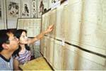
Over twenty wartime military maps showing evidence of the Japanese invasion of China were exhibited Saturday in Lanzhou, this capital city of northwest China's Gansu Province.
Drawn by the Japanese army, the maps cover various parts of the province, and some of the place names are still in use today.
Many local residents came to visit the exhibition. An unnamed visitor said, "the Japanese army drew the Chinese maps in such a detailed way, which clearly shows Japan had planned to occupy the area."
"The Japanese army sent numerous bombers to bomb Lanzhou from 1937 to 1941, attempting to destroy a steel bridge and cut the supply of goods to the region," said Chai Yuying, a professor with the Lanzhou College of Commerce.
Recently, as many as 136 confidential military maps of China once used by the Japanese army were found in this city, drawing a considerable number of experts and journalists to visit, sources said.

In This Section

|